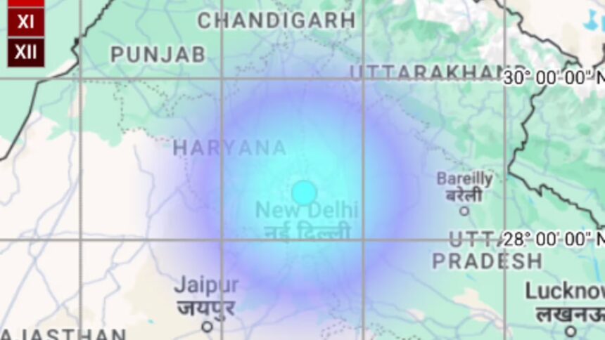
Residents in Delhi and the surrounding NCR areas woke up to tremors yet again on Thursday morning as an earthquake of 4.4 magnitude, with its epicentre in Haryana’s Jhajjar, shook the region. While there were no immediate reports of damage or casualties, the recurring tremors in the capital continue to raise concerns about its vulnerability, rooted in its location in a high seismic zone and its proximity to active fault lines and the Himalayas.
The National Center for Seismology (NCS) recorded the earthquake at 9:04 am at a depth of 10 km, with tremors felt across Delhi, Noida, Ghaziabad, Gurugram, and Faridabad, along with parts of Rajasthan and Uttar Pradesh. As people rushed outdoors seeking safety, social media was abuzz with residents sharing their experiences, with one person describing the shaking as something out of a “horror movie,” and another joking that the “capital of India should be shifted from New Delhi.”
Delhi’s seismic vulnerability and active fault lines
Delhi falls under Seismic Zone IV, indicating a high-risk area with fairly high seismicity. According to historical data dating back to 1720, only five earthquakes with magnitudes between 5.5 and 6.7 have been recorded in the region, while occasional earthquakes in the 7-8 magnitude range have also been reported.
The Delhi-Haridwar Ridge and Delhi-Moradabad Fault are two significant geological lineaments passing through the region, making it particularly sensitive to seismic activities. Other weak zones near Delhi identified by the National Center for Seismology include the Mahendragarh-Dehradun Subsurface Fault, the Sohna Fault, the Great Boundary Fault, the Delhi-Sargodha Ridge, and lineaments along the Yamuna and Ganga rivers. These faults increase the likelihood of tremors as stress accumulates along these fractures beneath the surface, leading to sudden releases that manifest as earthquakes.
Impact of the Himalayan region on Delhi’s seismic activity
Delhi’s proximity to the seismically active Himalayan belt further intensifies the risks. The Himalayas are still growing due to the collision between the Indian and Eurasian tectonic plates, and this constant tectonic activity results in stress accumulation, which periodically gets released in the form of earthquakes. These seismic releases can lead to tremors across northern India, including the NCR, even if the epicentre is located in nearby states.
The Delhi Disaster Management Authority (DDMA) notes that the classification of seismic zones is based on estimates drawn from earthquake occurrences, geological conditions, and tectonic structures of different areas. This process is continuously updated as new data becomes available, but the persistent tremors felt across Delhi-NCR serve as reminders of the urgent need for preparedness and structural resilience in the region.
Despite being located in a high seismic zone, many buildings in Delhi and NCR are still not adequately retrofitted to withstand earthquakes. Thursday’s tremors, like previous ones, sparked discussions about safety measures, urban planning, and building code compliance to mitigate potential damage in the event of a stronger earthquake in the future.
As the capital continues to experience tremors periodically, residents are reminded to remain aware of basic earthquake safety protocols and ensure that preparedness measures are in place to handle emergencies calmly, with safety of life as the priority whenever the ground shakes again.