In a historic leap for space technology and Earth science, NASA and ISRO’s joint mission, the NASA-ISRO Synthetic Aperture Radar (NISAR) satellite, has successfully deployed its massive radar antenna in orbit—marking one of the most critical milestones in its journey. Launched from India’s Satish Dhawan Space Centre on July 30, 2025, this $1.3 billion technological marvel is poised to revolutionize disaster prediction and environmental monitoring across the globe. Equipped with dual-frequency radars and designed to capture minute changes on Earth’s surface, NISAR is being hailed as a life-saving mission that will enable scientists, policymakers, and emergency managers to predict and respond to natural hazards with unprecedented accuracy. With its antenna now fully deployed, the stage is set for the satellite to begin delivering transformative data by October 2025.
A Technological Marvel in Earth Observation
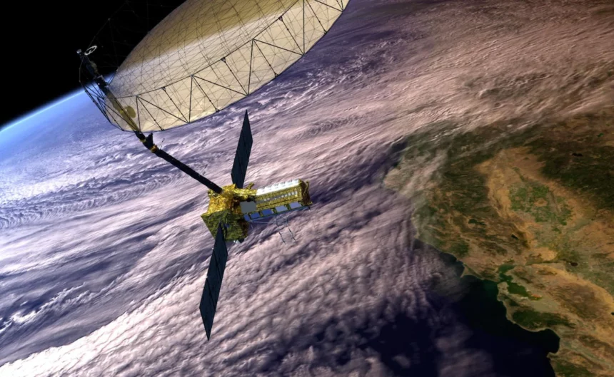
The deployment of NISAR’s radar antenna is a moment that has been eagerly anticipated by scientists and space enthusiasts worldwide. Weighing over 2.8 tons and built at a cost of $1.3 billion, NISAR is the most expensive civilian Earth observation satellite ever constructed. Its mission is as ambitious as it is essential—tracking changes in the Earth’s surface down to fractions of an inch, monitoring events such as earthquakes, landslides, volcanic eruptions, glacier shifts, and forest degradation. This fine-scale data will be a vital resource for disaster preparedness, infrastructure monitoring, climate change adaptation, and environmental protection.
Seventeen days after its launch aboard India’s GSLV-F16 rocket—a launch vehicle powered by an indigenous cryogenic engine that symbolizes India’s technological ascent—the satellite successfully unfurled its 12-meter radar antenna on August 15, 2025. This drum-shaped reflector, made of gold-plated wire mesh and supported by a nine-meter boom, is the largest antenna of its kind ever deployed for a NASA mission in low Earth orbit.
The unfurling process, poetically referred to as the “bloom,” involved a delicate combination of mechanical precision and space engineering ingenuity. Tension stored in the reflector’s flexible frame was released, followed by motorized activation, locking the antenna securely into its operational position. The antenna now serves as the main instrument directing microwave pulses from NISAR’s dual radar systems—NASA’s L-band radar and ISRO’s S-band radar—toward Earth, and collecting the return signals that allow for high-resolution imaging. Crucially, these radars can penetrate cloud cover, vegetation, and even heavy rain, ensuring data collection regardless of weather conditions.
Karen St. Germain, Director of the Earth Science Division at NASA Headquarters, hailed this milestone as transformative: “From innovative technology to delivering actionable science, NISAR’s capabilities will fundamentally change how communities prepare for and recover from disasters, maintain food security, and protect critical infrastructure.”
The mission’s potential impact stretches far beyond technical innovation—it represents a leap in the ability of humanity to observe, understand, and respond to the changing dynamics of our planet in near real time.
A Mission to Protect and Inform the World
NISAR’s capabilities are not just about impressive engineering; they carry a promise to safeguard lives and livelihoods. Dubbed a “life-saving mission,” NISAR will revisit almost every part of Earth’s land and ice surfaces every 12 days, producing 3D time-lapse maps of surface changes. These maps will be indispensable tools for tracking glacier retreat, predicting landslides, detecting ground subsidence, and assessing flood risks. Combined with meteorological data, NISAR could even forecast events like cloudbursts and glacier lake outbursts—phenomena that have recently wreaked havoc in the mountainous regions of India.
NASA’s Science Mission Chief Nicky Fox described NISAR as “a first-of-its-kind radar satellite that will change the way we study our planet and predict disasters before they strike.” NASA’s Deputy Associate Administrator Casey Swails underscored the diplomatic and cooperative value of the mission, calling it “a pathfinder for relationship building” between two major spacefaring nations.
India’s role in the mission is both symbolic and strategic. The GSLV-F16 rocket that carried NISAR into space highlights the country’s growing capacity to launch heavy payloads and conduct complex space missions. Its cryogenic engine, once a focal point of geopolitical restrictions, has now become a source of national pride and a contributor to global scientific advancement.
ISRO’s S-band radar complements NASA’s L-band radar, giving NISAR the ability to detect subtle changes in vegetation, soil moisture, and snow cover with unmatched precision. This dual-frequency system will allow researchers to gather diverse datasets from a single pass over any location, making NISAR one of the most versatile Earth observation tools ever deployed.
Indian Minister of Science and Technology Jitendra Singh congratulated the mission team via social media, emphasizing that “the mission will benefit the entire world community.” His statement captures the essence of NISAR’s design—it is not intended solely for one nation’s benefit but as a resource for all humanity.
Looking ahead, the next few months will focus on calibrating the radar instruments and preparing for full-scale science operations. By late October 2025, NISAR will begin transmitting data that can aid everything from tracking glacier melt in Antarctica to monitoring groundwater depletion in India’s agricultural heartlands.
Wendy Edelstein, NISAR’s Deputy Project Manager at NASA’s Jet Propulsion Laboratory, summarized the partnership’s significance: “NISAR is a 50-50 partnership between NASA and ISRO. It represents the largest collaboration of its kind and a model for future missions.”
In an age when climate change, environmental degradation, and natural disasters threaten communities worldwide, NISAR is more than just another satellite—it is a sentinel in orbit, a technological guardian capable of providing early warnings and guiding informed decision-making. It stands as a beacon of what can be achieved when nations work together, combining their expertise and resources in the service of global resilience and safety.