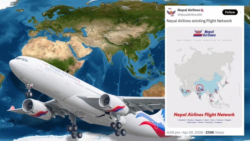
The controversy erupted after the airline shared a route network map intended to showcase its expanding international operations. However, observers quickly noticed the cartographic error, which misrepresented India’s territorial boundaries. Within hours, screenshots circulated widely across social media platforms, sparking intense public outrage and calls for accountability.
The issue escalated rapidly due to the deep political sensitivity surrounding Jammu and Kashmir, one of South Asia’s most disputed regions. In India, the depiction was widely viewed not as a minor technical mistake but as a serious misrepresentation of national sovereignty.
Online reactions intensified as hashtags calling for a boycott of Nepal Airlines began trending. Users demanded that India’s Ministry of External Affairs intervene and seek clarification from Nepal. The controversy quickly extended beyond social media, drawing attention from political commentators and public figures.
Territorial Sensitivity And Historical Context
The regions of Jammu and Kashmir and Ladakh have long held immense geopolitical significance. Since 1947, India and Pakistan have engaged in multiple conflicts over the territory, making its representation on maps highly sensitive.
For India, both regions are integral parts of the country, and any deviation in global or institutional maps often triggers strong responses. As a result, organizations operating internationally are expected to adhere strictly to established territorial norms when presenting geographic data.
In this context, the Nepal Airlines error carried significant diplomatic weight. Given Nepal’s close cultural, economic, and strategic ties with India, the incident raised concerns about the responsibilities of state-linked institutions in handling sensitive geopolitical representations.
Swift Apology And Damage Control
Following the backlash, Nepal Airlines acted quickly to contain the situation. The airline removed the controversial post and issued a public apology within 24 hours.
In its statement, Nepal Airlines acknowledged the error as a serious cartographic inaccuracy and clarified that it did not reflect the official stance of either the airline or the Nepalese government. The airline expressed regret for any offense caused and reaffirmed its respect for neighboring countries.
It also confirmed that an internal review had been initiated to understand how the incorrect map was published. This prompt response was seen as an effort to prevent further escalation and protect diplomatic relations.
Business Impact Amid Expansion Plans
The controversy comes at a crucial time for Nepal Airlines, which is actively expanding its operations in India. The airline has been increasing its presence on the Kathmandu–Delhi route and aims to boost flight frequency to meet rising travel demand.
India remains a key market for Nepal’s aviation and tourism sectors due to strong economic ties and high passenger traffic between the two countries. Any prolonged reputational damage could impact the airline’s growth strategy and customer trust in the region.
Maintaining positive public perception in India is therefore critical for Nepal Airlines, both commercially and strategically.
Public Reaction And National Sentiment
The backlash was further amplified by reactions from public figures, including Khesari Lal Yadav, who questioned whether such a significant error could truly be accidental.
His comments reflected broader public sentiment, with many users expressing disappointment and linking the issue to national pride and diplomatic sensitivity. Discussions also highlighted India’s longstanding support for Nepal in areas such as trade, infrastructure, and disaster assistance.
This emotional and political dimension contributed to the intensity of the reaction, transforming a technical error into a wider debate on bilateral relations and mutual respect.
Cartography And Modern Diplomacy
The incident underscores the growing importance of cartographic accuracy in today’s interconnected world. Maps are no longer just visual tools; they carry political, diplomatic, and symbolic meaning.
Errors in geographic representation can lead to serious consequences, including:
- Diplomatic tensions
- Public backlash and consumer boycotts
- Reputational damage for organizations
- Political controversy
For global companies and state-affiliated entities, ensuring accuracy in maps and visual communication has become essential, especially in regions with complex geopolitical histories.
Regional Implications
India and Nepal share a unique relationship characterized by open borders, cultural ties, and economic cooperation. However, issues related to territory and political perception have occasionally created friction.
While Nepal Airlines’ apology may help resolve the immediate situation, the episode highlights how quickly digital communication can amplify sensitive issues. It also serves as a reminder of the responsibilities institutions carry when operating across borders.
Conclusion
The Nepal Airlines map controversy illustrates how even a single visual error can escalate into a major geopolitical issue in a sensitive region like South Asia.
As the airline moves forward with its expansion plans, rebuilding trust and ensuring strict quality control in communications will be essential. For policymakers and institutions, the incident reinforces the importance of vigilance in an era where digital content can influence international perception instantly.
Ultimately, the episode stands as a clear example of how cartography, diplomacy, and public sentiment intersect in today’s global landscape.