A significant weather system originating from the Atlantic is set to bring severe gales and disruption to parts of the United Kingdom later this week, with a yellow wind warning issued by the Met Office for Friday and Saturday. The warning covers northern and western Scotland, as well as Northern Ireland, where gusts could reach up to 80mph (129km/h), with the possibility of stronger winds in some areas. This powerful storm is expected to bring widespread travel disruptions, power cuts, and localized damage, in addition to heavy rain and snow on higher ground, particularly in the hills of Scotland and northern England.
The storm will be a sharp contrast to the calm and relatively cold weather that has dominated the UK over the past week, marking a significant shift in the region’s climate. The powerful winds are the result of a dramatic change in the jet stream, which has been weak and diffuse in recent days, allowing high-pressure systems to keep more severe weather systems at bay. However, a sudden surge of Arctic air across North America has begun to energize the jet stream, and as it moves towards the UK, it brings with it the threat of powerful winds and stormy conditions.
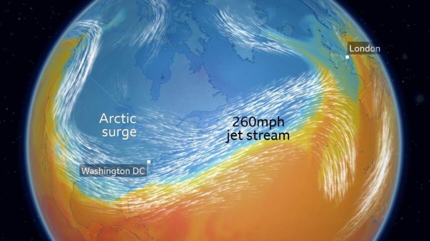
In North America, the clash between frigid Arctic air and milder southern air has already resulted in life-threatening wind chills and snowstorms across parts of the United States, even as far south as Texas and Louisiana. The extreme cold caused disruptions, including moving the inauguration of US President Donald Trump indoors—a rare occurrence, the first since 1985. The interaction of this cold air mass with the warmer air south of it is “supercharging” the jet stream, which is forecast to reach wind speeds of up to 260mph (418km/h) above the Atlantic.
This rapid intensification of the jet stream is causing a low-pressure system to deepen as it moves toward the UK, setting the stage for stormy weather. The Met Office has issued the yellow wind warning based on the predicted path and intensity of the storm, though uncertainty remains regarding the exact strength and location of the strongest gusts. As of now, the north-west of the UK appears to be at the greatest risk, but the exact details will become clearer in the coming days.
In addition to the wind, heavy rain is expected to spread across the UK, especially in the northern regions. While the south may experience milder conditions, temperatures will remain cold enough for snow to fall on higher ground in Scotland, northern England, and Northern Ireland. This storm could also bring about more turbulent weather conditions next week, with further low-pressure systems expected to approach the UK.
There is a possibility that this storm could be named, depending on its intensity and impact. The UK Met Office and Ireland’s Met Éireann typically assign names to storms when their potential to cause widespread disruption is high. The next storm on the naming list is “Éowyn,” and it is still uncertain whether this system will meet the criteria to be named. However, regardless of whether or not it is given a name, it is clear that the UK is about to experience a period of unsettled and challenging weather.
As the storm approaches, the Met Office urges people in the affected areas to stay informed and prepared for potential disruptions. With several days of wind and rain on the horizon, local authorities will continue to monitor the weather closely, and updates will be provided as new information becomes available. The public is encouraged to check the latest forecasts and follow warnings to stay safe as the storm impacts the UK later this week.